 On this map, yellow is Eastern Asia, blue is North Asia
The China Game from the Asia Society features geography-based questions about China and Chinese history.
For more information about Tibet, see Third Pole: Himalayas and Tibetan Plateau
- The Third Pole is a region of snow and glacial ice that provides fresh water for nearly one-third of the world's people (National Geographic, April 2010, p. 70).
Physical Geography of East Asia:

As seen above East Asia has a great variety of geographic formations.
- What can we infer about the different colors of the map based on their labels?
- Green is wet/vegetated
- Brown and crinkly looking are mountains, if smooth just high elevation
- Yellow means desert and dry
Track Live Expeditions on Mount Everest
The Himalayas cup the Plateau of Tibet (West of Himalayas)
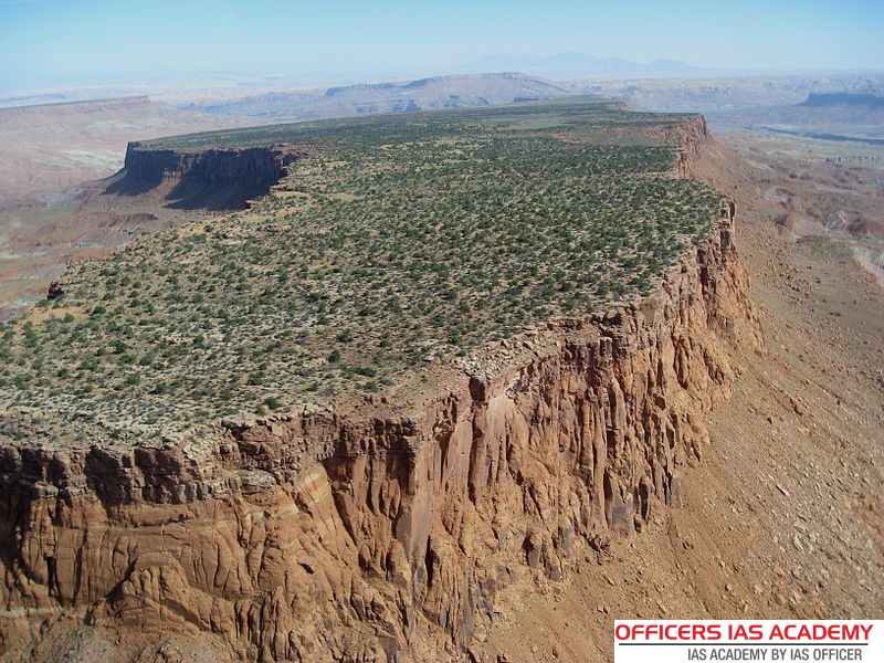
- A plateau is a flat elevated surface, almost as if a mountain had its peak chopped off! (see image below)
Population Maps and What They Can Tell Us
-
Population density is very important when studying a region
-
It allows us to determine where people are living within an area
-
It can further be used to help with inferences about the way of life of a region

Interactive Population Map of the World
North and East Asian nations bordering or containing the…
Pacific Ocean: (bordering) Japan and Taiwan
Arctic Ocean: (bordering) Russia
Sea of Japan: (bordering) North Korea, South Korea, and Japan
Yellow Sea: (bordering) China, North Korea, and South Korea
East China Sea: (bordering) China, Taiwan, and Japan
Gobi Desert: (contained by) China and Mongolia
Himalayas: run along the border between China and central Asian nations of India, Nepal, Bhutan, Pakistan, Afghanistan, Tajikistan, and Kyrgyzstan
Huang He (Yellow) River: (contained by) China
Chang Jiang (Yangtze) River: (contained by) China
Siberia: a region within Russia, running along its northeastern border with the Arctic Ocean
Yenisey River: (contained by) Russia (Siberia) running near the border with Mongolia
Lena River: (contained by) Siberia in northern Russia; this is one of the longest rivers in the world, and its delta is teeming with wildlife.
Kolyma River: (contained by) Russia (Siberia); the river is frozen for most of the year
Sources:
Book:
Geography: Realms, Regions and Concepts, H.J. de Blij and Peter O. Muller, John Wiley & Sons, Inc., 2008
Web sites:
The Plateau of Tibet:
https://www.britannica.com/place/Plateau-of-Tibet
Himalayas:
https://www.britannica.com/place/Himalayas
Gobi Desert:
http://wwf.panda.org/knowledge_hub/teacher_resources/best_place_species/current_top_10/gobi_desert.cfm
National Geographic article on the Lena River Delta
http://www.nationalgeographic.com/wildworld/profiles/g200/g160.html
story of a traveler’s journey rowing the length of the Yenisey River in Siberia
http://www.timcopejourneys.com/index.pl?page=44
more info on the Yenisey River
http://www.angusadventures.com/yeniseyriver.html
info on the Kolyma River
http://www.mapsofworld.com/russian-federation/geography/kolyma-river.html
pictures of the Kolyma River and other rivers by marine biologists (with group PARTNERS) studying rivers
http://ecosystems.mbl.edu/partners/kolyma.html
Maps:
U Tx libraries
http://www.lib.utexas.edu/maps/asia.html
http://academic.evergreen.edu/g/grossmaz/SPRINGLE/world-oceans-map.gif
http://www-rohan.sdsu.edu/dept/chinese/ICL2/chinamap.gif
http://encarta.msn.com/map_701513156/Himalayas.html
http://encarta.msn.com/map_701517782/Yenisey.html


 World History (Massachusetts)
.png) Grades 1 - 8 (Massachusetts)
Grades 1 - 8 (Massachusetts).png)
.png)
.png)
.png)

Comments (0)
You don't have permission to comment on this page.