Focus Question: How did the geographic location of ancient Rome contribute to the shaping of Roman society and the expansion of its empire?
Topics on the page:
Migration and Founding of Rome
Greek and Etruscan Influence
Terrain and Waterways
Territorial Expansion and Domination
Roman Roads and Bridges
- Bridges Across the Roman Empire
Aqueducts
Geography and Imperial Expansion
- Battle of Teutoberg Forest
- Battle of Carrhae
INTERACTIVE MAP:
Digital Atlas of Roman and Medieval Civilizations (DARMC)
- This useful and dense map allows students to toggle different parameters and components of the Roman Empire.
ACTIVITY:
Roman Empire Geography Activity by NatGeo
- "Activity Overview: Students use a physical map of the Roman Empire to investigate how physical geography contributed to economic and military power in ancient Rome."
- 50 minutes, grades 6-8, ages 11-14
Migration and Founding
Very little is known about the early history of the city of Rome. One theory holds that Rome was first settled by Indo-Europeans who migrated south over the alps and settled in a series of hilltop villages along the Tiber River. During this time period, archaeology shows that central Italy and Northern Italy was dominated by a culture known to the Romans as the Etruscans.
- It is believed these peoples were not of Indo-European descend, but that they migrated to Italy from the Near East. The early Romans might have adopted Etruscan customs into their own culture.
 |
| The Seven Hills of Rome |
The hills of Rome supported Wheat cultivation as well as the cultivation of Olive trees, fruit trees, and vineyards.
- The River Tiber offered resources for tribes to settle along it. They later joined together, beginning the creation of Rome.
- In order to combat the Malaria problems of the nearby swamps, the Romans were forced to drain and pave the wetlands near Rome.
- From early in Roman history, the Romans learned the importance of engineering, a trait that would later be a cornerstone of their Imperial power.
Good handout on the early peoples of Rome; touches on the Romulus and Remus myth but focuses on archaeological information for early Rome.:
 reading-FoundingofRome.pdf
Every History has mystery! Click here to watch a short video about the myth of Romulus and Remus.
- Question to Consider:
- How does the combination of fact and myth shape our understanding of the past?
Greek and Etruscan Influence
Due to it's location in central Italy, early Rome was influenced both by the Etruscan culture as well as their extensive contact with the Greek city-states in southern Italy.
Here is an interactive map of the known Etruscan archaeological sites. See also The Origins of the Etruscans, Thayer Watkins, San Jose State University.

(Above: Note that before Rome rebelled against its Etruscan King, it was a territory of greater Etruria)
Terrain and Waterways (compared with Greece)
Without the rugged mountain ranges of Greece to hold them back, Rome's flatlands were far more extensive and agriculturally productive, allowing it to support a large population. Some of these agricultural centers were the Po River valley in the north, the Plain of Latium on which Rome was located, and Campania to the south of Latium.
Located eighteen miles inland on the Tiber River, Rome had access to the sea yet was far enough inland to be safe from pirates.
Built on seven hills, it was easily defended. Since the Tiber could be readily forded, Rome, located near the mouth of the Tiber, became a natural crossing point for north-south traffic in western Italy.
The Italian peninsula also juts into the Mediterranean, making this region an important crossroads between the western and eastern ends of the Mediterranean sea.
Territorial Expansion and Domination in the Western Mediterranean

Despite some early trade with the Greek colonies in Italy, Rome was far from being a preeminent trading power. However, as Rome grew as an Empire, it came into conflict with the trading giant of the Western Mediterranean, the Republican Empire of Carthage (See Map).
Punic Wars (video: part 1 and part 2)-
- After conquering Central and Southern Italy, Rome set its sights on Sicily, an agriculturally rich island separated by a small channel from the southern tip of Italy. However, the Carthaginian Empire already claimed the island.
- The two, inevitably, came into conflict. It was in this conflict that Rome was required to build a sizable navy to compete with Carthage and began to emerge as a major power, not only in the Italian peninsula, but also in the broader Mediterranean Sea.
- Prior to the Punic Wars, Rome had never seen conflict away from the mainland; therefore, it had to build its naval power from scratch. This articledetails the Roman Navy's rise to dominance.
- When Rome finally conquered and colonized Carthage's capital (located in modern-day Tunisia), it eliminated a powerful trading Empire but gained it's territories, becoming the successor to its trading legacy.
- The Punic Wars and the conquests of Sicily and Carthage were of enormous importance to the expansion of Roman trade, Naval and Economic power. With the destruction of Carthage, Rome became the preeminent Empire in the Western Mediterranean.
 Click here for Information about Phalanx Warfare and its impact on Roman Expansion
Click here for a video which details the brutal Punic Wars between Carthage and Rome and watch the moment that the famous Carthaginian general, Hannibal, nearly destroyed the fledgling Roman Republic.
Rome's dominance against Carthage in the Punic Wars demonstrated the power of Rome's system of alliances. Rome's Italian "allies" bore a large brunt of the fighting against Carthage and contributed greatly to the Roman victory.
As Rome's power grew, it became a center of trade. Roman military conquest brought wealth and plunder to the capital from all the corners of the Mediterranean, which attracted merchants and artisans to the city.

- Click here for an excellent interactive map from Stanford University that shows Roman trade routes and allows the user to calculate travel times and distances based on a variety of factors.
- Click here for an interactive map on the history of the Roman Empire
- Click here for interactive maps on the Seven Hills of Rome, the spread of Christianity throughout the empire, and more!
 |
| Roman Trade Routes |
- See also Standard 7.43 for engineering contributions of Roman civilization
As the popular saying goes, "All roads lead to Rome" - and of course they did.
- As Rome's economy grew, it needed better roads over which to transport goods and people,especially to its central city.
- The importance of roads to the empire cannot be understated.
- Roads helped Rome quickly move troops and supplies throughout its territory, facilitate trade, and interconnect its conquered provinces, bringing them into the broader Roman whole.
- At one point in its history, Rome had 50,000 miles of roads. This system allowed Romans to easily access the far reaches of their Empire, from Spain to Greece.
Bridges Across the Roman Empire
Roman Alcántara Bridge across the River Tajo, Cáceres Province, Extremadura, Spain
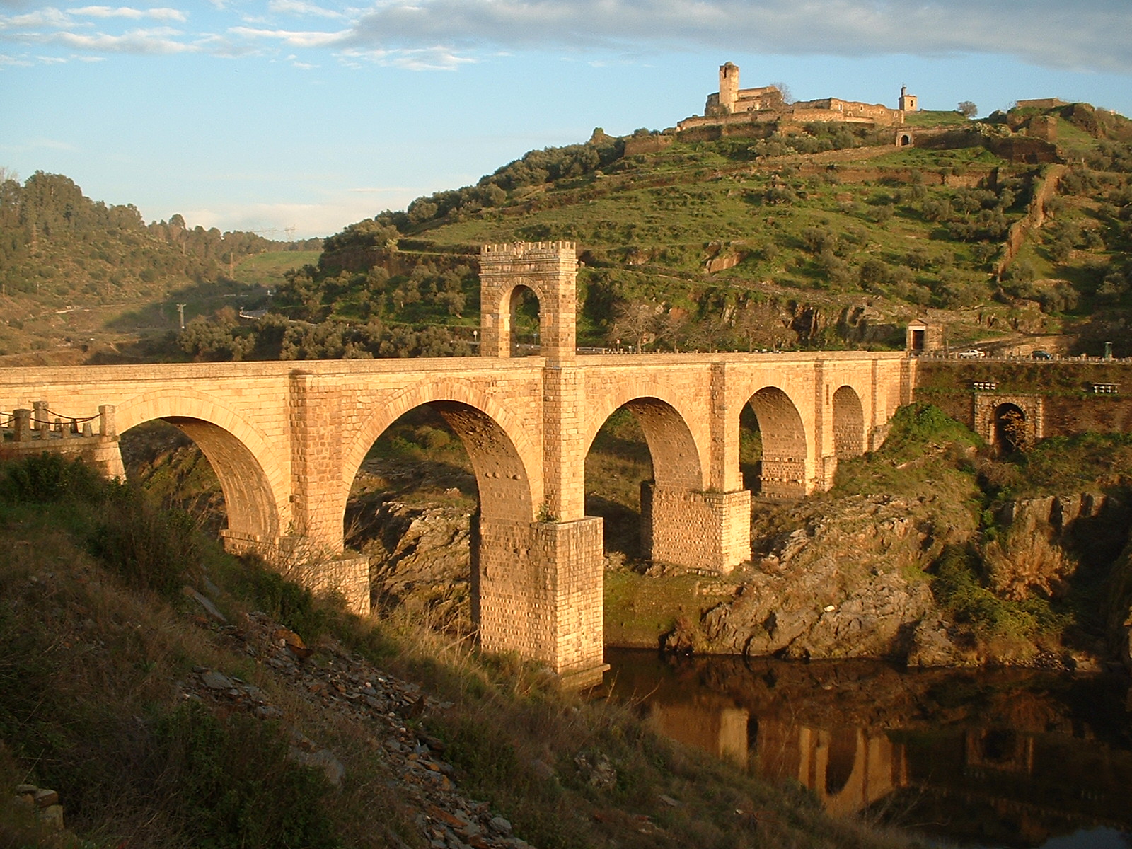
- One of the lasting legacies of the Roman Empire is their infrastructure. The traces of Roman roads are found all over the area of the former empire. Along these grand routes are bridges that prove the Roman intelligence and strength.
- While Roman roads are found throughout the entire footprint of the empire, roman bridges are as well
- An interactive map created by Harvard allows users to view certain structures and components of the Empire, including verified Roman bridges:
- Northernmost bridge: Trier, Germany
- Westernmost bridge: Lisbon, Portugal
- Easternmost bridge: Outside of Termez, Uzbekistan
- Southernmost bridge: Fars Province, Iran
- Many of these bridges are still in use today, while ruins of the others stand as landmarks of the empire's presence across Europe, Northern Africa, and Asia Minor.
- Constructed between 104 and 106 AD, the Alcántara Bridge in Alcántara, Spain has withstood nearly two millennia of the elements and attempted destruction. After minor restorations, the bridge is still used today and can withstand all modern vehicles.
- These feats in infrastructure were responsible for the social, political, and economic connection of the vast empire
Aqueducts
Aqueducts built by the Romans were one of the most impressive feats of ancient civilization.
- The accessibility of water that aqueducts provided altered Roman society and allowed for expansion. The geography facilitated the construction of aqueducts because of the many bodies of water that were located at high altitude from which these structures originated before running into cities.
- The higher the altitude of the original body of water the greater the water pressure flowing through the aqueduct. The aqueducts were able to transport water from surrounding areas into Rome and other cities of the Roman Empire.
- Most importantly it allowed clean drinking water for a population that was growing rapidly. The abundance of water transported by the aqueducts helped create a Rome that was infatuated with water.
- The aqueducts supplied water to the public baths that many Roman people used. The Romans also constructed a sewer system including the Cloaca Maxima that helped to drain water from Rome into the Tiber River, hence avoiding much of the waste-born disease that plagued the cities of antiquity.
- The aqueducts were a commodity that many of Roman colonies wanted access to and
 thus were often more prone to accept Roman domination because of this technological upgrade. Therefore aqueducts helped aid the expansion of Roman power along with shaping Roman society.
- Click here to play the construct your own aqueduct game
- Click here to view an interactive tour of the famous Baths of Caracalla.
How Geography helped Contain Roman Imperial Ambitions
Rome continued its conquests until further military expansion put a strain on Roman manpower and resources.
- The Sahara desert kept Rome from expanding too far into Africa, while the thick forests stopped Roman attempts to conquer Northern and Central Europe.
- When Emperor Augustus attempted to conquer the region Germania, three entire legions of Romans were massacred at the Battle of Teutoberg Forest.
- The Germanic tribesmen were not as well trained or equipped as the Roman Legionaries, but they had the advantage of knowing the dense forest and how to ambush foes using hit and run guerrilla tactics.
- Likewise, conquering Persia to the East proved difficult.
- A combination of long supply lines, hostile deserts, and powerful eastern enemies prevented Rome's eastward expansion into Mesopotamia.
- When Roman Consul Marcus Crassus attempted an invasion of the Parthian (Persian) Empire, he and his seven legions were butchered in the Battle of Carrhae. This was one of the worst defeats in Roman military history.
Sources:
http://www.fsmitha.com/h1/ch15.htm
http://resourcesforhistory.com/map.htm
http://www.icsd.k12.ny.us/legacy/highschool/socstud/global2_review/ancient_rome.htm
http://www.historylearningsite.co.uk/romulus_and_remus.htm
http://www.unrv.com/culture/roman-roads.php
http://www.unrv.com/culture/roman-aqueducts.php
http://www.historylearningsite.co.uk/romulus_and_remus.htm
http://www.historyguide.org/ancient/lecture10b.html
http://edtech2.boisestate.edu/brandonworkentin/502/virtualtour/alcantara.html
https://en.wikipedia.org/wiki/Alc%C3%A1ntara_Bridge#/media/File:Bridge_Alcantara.JPG
http://ags.cga.harvard.edu/darmc/


 World History (Massachusetts)
.png) Grades 1 - 8 (Massachusetts)
Grades 1 - 8 (Massachusetts).png)
.png)
.png)
.png)

Comments (0)
You don't have permission to comment on this page.